

Manage overcrowding
Identify peak times and heavily used areas
Measure visitor flows with a simple, privacy-friendly system designed for outdoor environments.
Learn how it works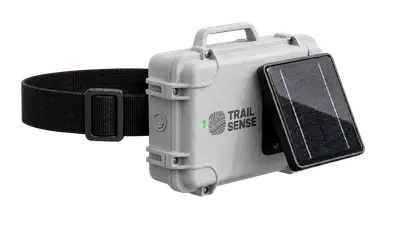
The system is designed for easy deployment in remote areas.
Many municipalities and tourism regions don’t have accurate data on how their trails are used. Existing solutions are often expensive, difficult to maintain, or not designed for remote environments.
As a result, important decisions are often based on assumptions instead of real data.
Trailsense provides an easy way to measure visitor flows using small, off-grid sensor nodes. The system works without cameras and does not collect personal data.
Trailsense detects anonymous WiFi signals from nearby devices and converts them into aggregated visitor counts.
Sensor nodes detect WiFi signals from nearby smartphones.
Data is processed directly on the device and anonymized.
Only aggregated counts are sent via mobile network.
Data is visualized in a dashboard with daily and hourly trends.

The system was tested in a pilot project on a hiking trail leading to the Arzler Alm.
Two sensor nodes were installed:
This allowed us to validate the system and compare the results with an established solution.
Instead of relying on assumptions, you gain clear insights that support planning, improve visitor experience, and help protect natural areas.
Identify peak times and heavily used areas
Use data to support investments and maintenance
Monitor usage and react early to environmental pressure
No personal data collection
We offer tailored setups depending on your needs and trail network. Get in touch with us to discuss your use case or request a demo.